
Accuracy assessment of EnMap-Box machine learning algorithms for land use and land cover classification using Landsat imagery
Article Sidebar
Main Article Content
Abstract
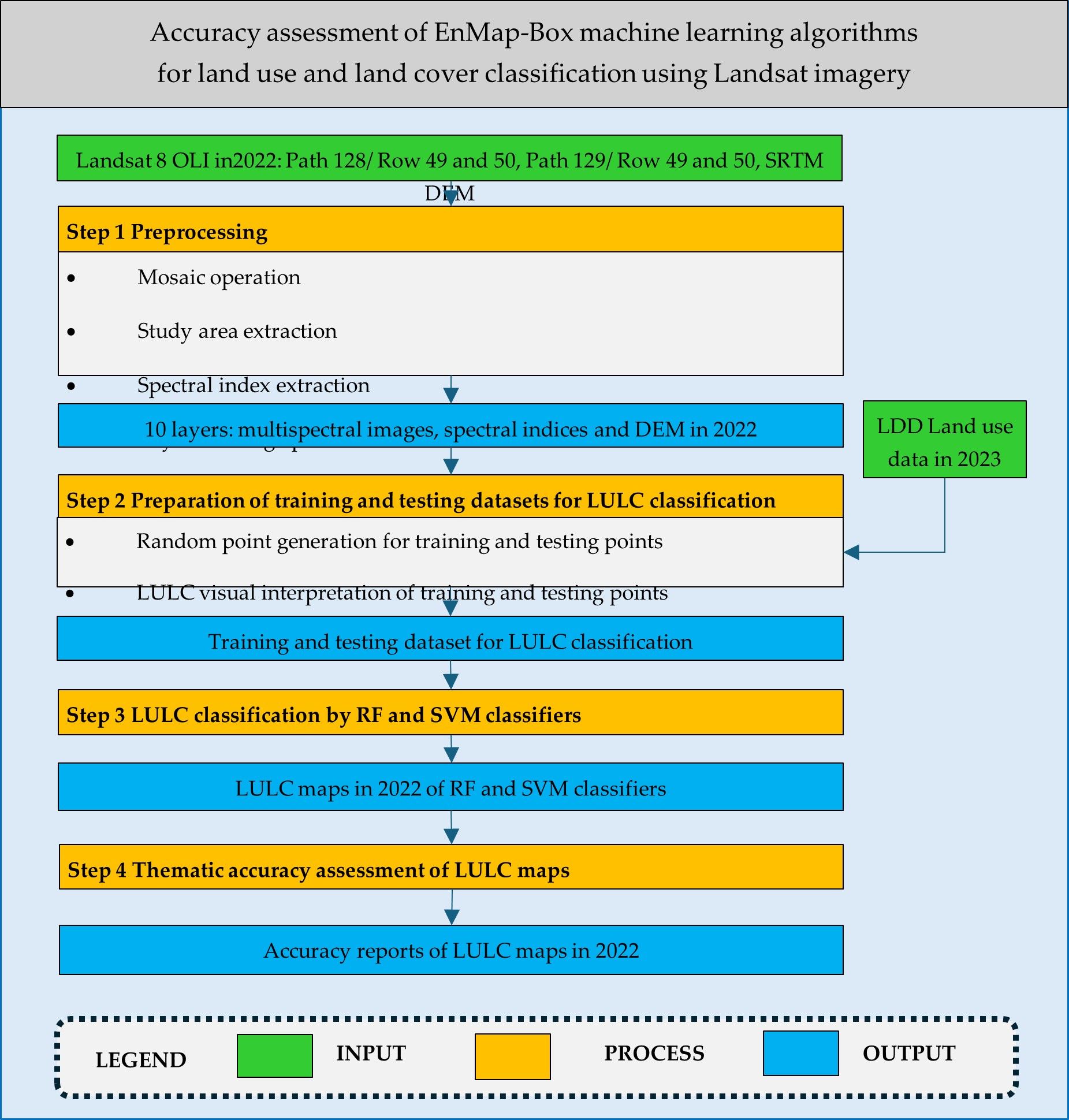
Land use and land cover (LULC) is essential information for multiple users across multidisciplinary sciences. Currently, free downloads of remote sensing data and public software with novel algorithms are available for LULC classification by scientists and researchers. The study’s objectives were (1) to classify and map LULC data for 2022 using random forest (RF) and support vector machine (SVM) classifiers and (2) to assess the thematic accuracy of classified LULC maps with RF and SVM classifiers. The research methodology comprised four significant steps. As a result, the nine LULC classes classified in 2022 using RF and SVM achieve overall accuracy values above 90% and Kappa-hat values above 87%. According to the pairwise Z-test, nine decision tree numbers for RF and 12 combinations of g and C parameters for SVM can classify LULC data for 2022 with insignificant differences in Khat values. In this study, the optimal number of decision trees for LULC classification using RF was 150. Meanwhile, the most suitable parameter for LULC classification by SVM was the Gaussian radial basis function kernel with a g value of 0.01 and a C value of 0.1. However, to apply the EnMap-Box for LULC classification, preparing the training and testing datasets is an important step, and users must collect them carefully. Nevertheless, the research methodology can serve as a guideline for classifying land use and land cover information from Landsat imagery using the EnMap-Box software for urban and land-use planning.
Article Details

This work is licensed under a Creative Commons Attribution-NonCommercial-NoDerivatives 4.0 International License.
References
Jensen RJ, Botchway K, Brennan-Galvin E, Johannsen C, Juma C, Mabogunje A, Miller R, Price K, Reining P, Skole D, Stancioff A, Taylor RFD. Down to Earth: Geographic Information for Sustainable Development in Africa. Washington: National Research Council. 2002.
Turner BL, Lambin EF, Reenberg A. The emergence of land change science for global environmental change and sustainability. Proc Natl Acad Sci. 2007;104:20666–20671.
Song X-P, Hansen MC, Stehman SV, Potapov PV, Tyukavina A, Vermote EF. Global land change from 1982 to 2016. Nature. 2018;560:639–643.
Liu H, Gong P, Wang J, Clinton N, Bai Y, Liang S. Annual dynamics of global land cover and its long-term changes from 1982 to 2015. Earth Syst Sci Data. 2020;12:1217–1243.
Geoawesome.com. List of Top 10 Sources of Free Remote Sensing Data. [Internet]. 2025 [cited 2025 May 31] Available from https://geoawesome.com/eo-hub/list-of-top-10-sources-of-free-remote-sensing-data/
Gisgeography.com. 13 Open Source Remote Sensing Software Packages. [Internet]. 2025[cited 2025 May 31] Available from https://gisgeography.com/open-source-remote-sensing-software-packages/
van der Linden S, Rabe A, Held M, Jakimow B, Leitão PJ, Okujeni A, Schwieder M, Suess S, Hostert P. The EnMAP-Box—A toolbox and application programming interface for EnMAP data processing. Remote Sensing. 2015;7:11249-11266.
EnMap. EnMAP-Box Documentation. [Internet] 2025 [cited 2025 May 31] Available from https://www.enmap.org/data_tools/enmapbox/
Gislason PO, Benediktsson JA, Sveinsson JR. Random forests for land cover classification. Pattern Recognit Lett. 2006;27:294–300.
Szuster BW, Chen Q, Borger M. A comparison of classification techniques to support land cover and land use analysis in tropical coastal zones. Appl Geogr. 2011;31(2):525–532.
Rodriguez-Galiano VF, Ghimire B, Rogan J, Chica-Olmo M, Rigol-Sanchez JP. An assessment of the effectiveness of a random forest classifier for landcover classification. ISPRS J. Photogrammetry Remote Sens. 2012;67:93–104.
Pelletier C, Valero S, Inglada J, Champion N, Dedieu G. Assessing the robustness of Random Forests to map land cover with high-resolution satellite image time series over large areas. Remote Sens Environ. 2016;187:156–168.
Ghorbanian A, Kakooei M, Amani M, Mahdavi S, Mohammadzadeh A, Hasanlou M. Improved land cover map of Iran using Sentinel imagery within Google Earth Engine and a novel automatic workflow for land cover classification using migrated training samples. ISPRS J Photogrammetry Remote Sens. 2020;167:276–288.
Pal M, Mather PM. Support vector machines for classification in remote sensing. Int J Remote Sens. 2005;26(5):1007–1011.
Camps-Valls G, Gomez-Chova L, Munoz-Mari J, Rojo-Alvarez JL, Martinez-Ramon M. Kernel-based framework for multitemporal and multisource remote sensing data classification and change detection. IEEE Trans Geosci Remote Sens. 2008; 46(6): 1822-1835.
Kavzoglu T, Colkesen I. A kernel functions analysis for support vector machines for land cover Classification. Int J Appl Earth Obs Geoinf. 2009;11(5):352–359.
Christovam LE, Pessoa GG, Shimabukuro MH, Galo, MLB T. Land Use and Land Cover Classification Using Hyperspectral Imagery: Evaluating the Performance of Spectral Angle Mapper, Support Vector Machine and Random Forest. ISPRS - Int Arch Photogramm Remote Sens Spat Inf Sci. 2019;XLII-2/W13:1841–1847.
Swetanisha S, Panda AR, Behera DK. Land use/land cover classification using machine learning models. Int J Electr Comput Eng (IJECE). 2022;12(2):2040.
Rouse JW, Haas RH, Schell JA, Deering DW. Monitoring vegetation systems in the Great Plains with ERTS. In Proceedings of the 3rd Earth Resource Technology Satellite (ERTS) Symposium; 1974.
Xu H. Modification of normalized difference water index (NDWI) to enhance open water features in remotely sensed imagery. Int J Remote Sens. 2006;27(14): 3025–3033.
Zha Y, Gao J, Ni S. Use of Normalized Difference Built-up Index in Automatically Mapping Urban Areas from TM Imagery. Int J Remote Sens. 2003;24(3): 583–594.
Breiman L. Random Forests. Mach Learn. 2001;45(1):5–32.
Mansour M, Mutanga O, Everson T, Adam E. Discriminating indicator grass species for rangeland degradation assessment using hyperspectral data resampled to AISA Eagle resolution. ISPRS J Photogramm Remote Sens. 2012;70:56–65.
Breiman L, Cutler A, Random Forests. [Internet]. 2025 [cited 2025 May 31] Available from https://www.stat.berkeley.edu/~breiman/RandomForests/cc_home.htm
Huang C, Davis LS, Townshend JR. An assessment of support vector machines for land cover classification. Int J Remote Sens. 2002;23(4):725–749.
Foody GM, Mathur A. A relative evaluation of multiclass image classification by support vector machines. IEEE Trans Geosci Remote Sens. 2004;42(6):1335–1343.
Foody GM, Mathur A. The use of small training sets containing mixed pixels for accurate hard image classification: Training on mixed spectral responses for classification by SVM. Remote Sens Environ. 2006;103(2):179–189.
Hsu CW, Chang CC, Lin CJ. A practical guide to support vector classification. Department of Information and Research, National Taiwan University. 2025.
Shao Y, Lunetta R S. Comparison of support vector machine, neural network, and CART algorithms for the land-cover classification using limited training data points. ISPRS J Photogramm Remote Sens. 2012;70:78–87.
Congalton RG, Green K. Assessing the Accuracy of Remotely Sensed Data: Principles and Practices. 2nd Edition. Boca Raton: CRC Press. 2008.
Land Development Department. (LDD). Land use data in 2023. Land Development Department. 2023.
Fitzpatrick-Lins K. Comparison of sampling procedures and data analysis for a land-use and land cover map. Photogrammetric Engineering and Remote Sensing. 1981;47(3): 343–351.
Rosenfield GH, Fitzpatrick-Lins K. A coefficient of agreement as a measure of thematic classification accuracy. Photogrammetric Engineering and Remote Sensing. 1986;52(2): 223-227.
Anderson JR, Hardy EE, Roach JT, Witmer RE. A land use and land cover classification system for use with remote sensor data. Washington: Geological Survey of United States. 1976.
Phinyoyang A. Optimized land use and land cover allocation for flood mitigation with goal programming, Mueang Chaiyaphum district, Chaiyaphum province, Thailand. [Dissertation]. Nakhon Ratchasima, Suranaree University of Technology; 2021.
Kulsoontornrat J. An optimal scenario of land use and land cover allocation to minimize sediment and nutrient export, Upper Ing watershed, Phayao province. [Dissertation]. Nakhon Ratchasima, Suranaree University of Technology; 2021.
